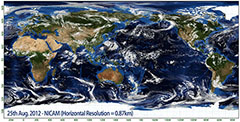
Researchers at the RIKEN Advanced Institute for Computational Science (AICS) in Kobe, in cooperation with colleagues from the Japan Agency for Marine-Earth Science and Technology and the University of Tokyo, have succeeded in creating a new stunningly precise simulation of cloud formation using a high-resolution atmospheric model. The simulation, based on the K computer, uses grids spaced less than 1 km apart and covering the entire world. Previous simulations had a resolution of just 3.5 km. The results are expected to allow more accurate predictions of weather phenomena including typhoons and sudden rainfall, which involve cumulonimbus clouds, commonly known as thunderclouds, which are caused by convective cells.
The team began the simulation using data from a historical date—12:00 UST on August 25, 2012—and then ran the simulation at various resolutions, from 3.5 km—the scale available on the Earth Simulator—down to 0.87 km, and then compared these simulations to the actual historical progress of weather phenomena, which included a typhoon in the northern Pacific. They showed that as the resolution fell under 2 km, the predicted movements of thunderstorm-causing convections and their actual movements became much closer.
The simulation is a modification of the Nonhydrostatic Icosahedral Atmospheric Model (NICAM), which was originally run on the Earth Simulator, to the much more powerful K computer.
The results have been published in Geophysical Research Letters. DOI: 10.1002/grl.50944